


PDF lesson plan
KS2
Years 3-6
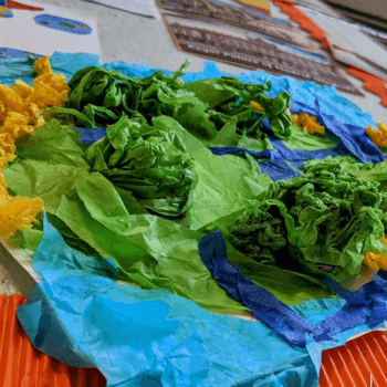
Use a range of modelling materials to turn the topographical (and other) features of a place of study into a tangible model in this crafty spin on a geography KS2 lesson.
Retain the geographical integrity of the curriculum and get pupils to use maps to identify features (including relief).
In addition, this lesson will allow them to express their understanding of this tangibly, through craft and hands-on learning.
The lesson can be applied to any location you may be studying, and can also be adapted to focus in as much or as little detail as you feel is suitable for your class.
It’s especially effective as an opportunity to explore the relief of an area studied, and allows you to make more meaning of a region’s land formation in comparison to the confines of a 2D map.
National curriculum geography KS2
The national curriculum for geography KS2 states that pupils should:
- Understand geographical similarities and differences through the study of human and physical geography of a region of the United Kingdom, a region in a European country, and a region within North or South America.
- Use maps, atlases, globes and digital/computer mapping to locate countries and describe features studied.
What they’ll learn
- About the topographical features of a featured location
- How to interpret and articulate the meaning of maps
- To explore the ways to show height on a map
- The difference between human and physical geography
- To identify features of physical geography in a location studied
Adam Jevons-Newman is the deputy headteacher and curriculum leader at a primary school in Nottinghamshire. Follow Adam on Twitter @JNCurricEdu
Similar resources
- Shakespeare rap – Write, perform and master metre
- Stone Age to Iron Age – KS2 medium-term plan with resources
- Buddhism charity KS2 – Explore dāna (Buddist generosity concept)
- Solubility KS2 – Investigate solubility with common ingredients
- Fast fashion effects on environment – Fashion show art lesson