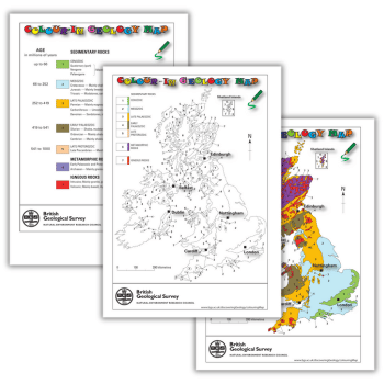
Download this free colour-in geology map of Britain and Ireland to help students learn about the eras of the Phanerozoic Eon and the Late Proterozoic Eon.
You can also use this geology map of Britain to help pupils learn when the sedimentary rocks of the UK and Ireland were formed.
The worksheet also explains how we group together periods into eras. Periods are the basic unit of geological time. Major geological events, such as a mass extinction, separate them.
| Age in millions of years | Era | Period | Sedimentary rock type |
| up to 66 | Cenozoic | Quaternary (part) Neogene Palaeogene | Mainly clays and sands |
| 66 to 252 | Mesozoic | Cretaceous Jurassic Triassic | Mainly chalk, mudstones and sandstones Mainly limestones and mudstones Mudstones, sandstones and conglomerates |
| 252 to 419 | Late Palaeozoic | Permian Carboniferous Devonian | Mainly magnesian limestones, mudstones and sandstones Limestones, sandstones, shales and coal seams Sandstones, shales, conglomerates, slates and limestones |
| 419 to 541 | Early Palaeozoic | Silurian Ordovician Cambrian | Shales, mudstones, sandstones; some limestones Mainly shales and mudstones; limestone in Scotland Mainly shales, slate and sandstones; limestone in Scotland |
| 541 to 1000 | Late Proterozoic | Late Precambrian | Mainly sandstones, conglomerates and siltstones |
The British Geological Survey is the UK’s premier provider of objective and authoritative geoscientific data, information and knowledge. Browse more resources from BGS. Visit its website at bgs.ac.uk. You can also follow on X at @BritGeoSurvey.


